|

Platbooks |
 |
|
Click here to review the online plats:
For each plat (except that of 1875, where images are not shown):
Or read further to immerse yourself in plat details...
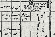
A plat is a map which shows the ownership and size of each major parcel of land within a county.
But what is a 'major parcel'? Typically (at the discretion of the plat publisher) a 'major parcel' is one of an acre or more; that is, one which is large enough to be drawn, and which, when drawn, will provide enough 'paper space' to include some indication of size and ownership. Because of this, city properties are not typically shown, and plats are therefore of greatest interest to those who are tracking multi-acre agricultural properties.
A plat has no legal significance; that is, it is an indication -- but not a guarantee -- of the ownership of land at a 'blurred' point in history. The 'blurring' occurs because of the unofficial nature of the plat; it is not the product of the county government, but rather of an outside party, typically a map company that specializes in such work. The plat company bases a new map on a previous one (if available), and then augments and corrects the previous edition based on the subsequent title records and property tax payments in the county. Therefore, because of the iterative and progressive nature of plat development, a given edition represents a 'best representation' of the ownership of significant properties within the year of publication, but which does not necessarily represent the ownership of the properties on any specific date.
So, if a plat has no legal significance - what good is it?
To genealogists, a plat can be of great value, in that it provides strong evidence of a family's residence in a given year. Multiple plats, spaced over the years and decades, show the ebb and flow of families as they arrive in a community, marry offspring of those in surrounding clans, and then prosper or disappear.
Of further importance, plats were published irregularly, which means that they rarely reflect a ten-year census cycle; instead, they provide valuable updates between these ten-year federal snapshots.
I am not aware of a comprehensive catalog of Moultrie plats. The earliest that I've seen is that of 1875, available at Eden Martin's web site. I suspect that this may, in fact, be the first. Moultrie was founded only in 1844 and, during its 17 years of antebellum existence, it was quite the frontier; that is, it was hardly the mature society that would support the investment required of a plat. In the new post-war world, however, central Illinois -- with the rest of the Midwest -- became the breadbasket of the nation, a font of agrarian wealth ready for documentation.
In addition to the 1875 plat, one was published in 1896 (of which I have not been able to obtain a copy), and another in 1913, reproduced here from photocopies of microfilm. Finally, I have original plats from 1942, 1949, 1953, and 1960 in my own collection. These late editions are, unfortunately, closely bunched within a 17-year period, and do not therefore reveal the cross-generational movement that might be desired.
In order to understand some of the terminology of plats (and other documents, such as Federal Land Grants and titles), you should understand:
For the moment, ignore the fact that the earth is a sphere and, instead, assume that it is flat. This makes things simpler, and we'll get back to the problems that 'sphericallity' causes a bit later. We'll therefore ignore the third point for a bit, and tackle the first two.
Land, as least as it was measured in the Midwest states, was -- and is yet today -- delineated in townships and sections. A township -- or specifically a geographic township (we'll talk about civil townships in a bit) -- is plot of land, six miles (more or less) on a side. That is, it comprises about 36 square miles. Each of the 36 (approximately) square-mile parcels of this township is a section of (about) 640 acres. The 'about' and 'approximately' become important when we later consider the curvature of the earth.
Each of these geographic townships was (and still is, since these remain the legal basis of land descriptions in Moultrie) located in terms of its distance from a reference point. That is, each was defined in terms of its distance east or west (a 'Range' number) and north or south (a 'Township' number) from a defined point.
So where is this reference point?
When the great westward migration began, there were no preexisting landmarks, and the federal government (titular owner of the as-yet unclaimed lands) realized that a new method of description was required. The result was the Land Ordinance of 1785. This act stated:
"The surveyors as they are respectively qualified shall proceed to divide the said territory into townships of six miles square, by lines running due north and south, and others crossing these at right angles, as near as may be."
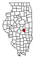
The reference point by which Moultrie County is defined is located at the intersection of the 'Third Principal Meridian' (a north/south line drawn through the junction of the Ohio and Mississippi rivers) and the 'Centralia Baseline', an east/west line which passes near (actually a mile or so south of) Centralia.
The map below shows the baselines and meridians in Illinois, as well as Moultrie's position in relation to the intersection of the Centralia baseline and the third meridian. It also shows how the sections are numbered within a geographic township, starting at the northeast corner and zigzagging south to the southeast corner. The description of land (at least, in much of the Midwest) is given in terms of these three attributes, e.g. "Section 32, in Township fourteen North of the baseline of Range five East"

The map above shows that townships in Moultrie fall between Ranges 4 through 6 (west to east) and Townships 12 through 15 (south to north). That is, there are three sections of land -- Ranges 1 through 3, or about 18 miles -- between the Third Meridian to the west and the western borders of Dora and Marrowbone, and 11 sections -- sections 1 through 11, or approximately 66 miles -- between the Centralia Baseline and the southern border of Whitely.
But what is this 'approximately' and 'about'? Resolving this question requires discussion of the third issue mentioned earlier, that is: the earth is a sphere.
Flat, perfect checkerboards don't match the surface of a ball. Try, for instance, to gift-wrap a basketball with wrapping paper; you will not be able to wrap it tightly around the ball without wrinkling the paper. In a very local sense, the earth is flat and, within very local boundaries (say, within a single county), the perfect 6-mile-square pattern specified in 1785 seems to work satisfactorily. However, over even slightly longer distances (like that from centralia to Moultrie), the 'wrinkles' begin to appear and need to be accounted for.
These 'wrinkles' are apparent in the plat of Moultrie shown below: most of the county is laid out in apparently perfect squares, but the original government surveyors made geometric adjustments in three places:

This map also illustrates the difference between geographic and civil (governmental) townships: In Moultrie County, only the civil townships of Lowe, Jonathan Creek , and East Nelson exactly comprise a geographic township. Dora, Lovington, Marrowbone, and Whitley each overlap two, and Sullivan includes, in whole or in part, three.